
Storm Doris: 60-80mph winds to hit UK on Thursday
Storm Doris, the fourth named storm of this autumn/winter season, is going to hit the UK during the daytime on Thursday.
Even though the storm will move through quickly, there is expected to be a spell of gales across a large swathe of the UK, with the potential to bring disruption.
Storm Doris’ arrival will come at a time when a more unsettled spell of weather is affecting the UK, following what has generally been a settled few weeks.

How strong will the winds be?
At the moment, the winds are expected to pick up through Thursday morning, peaking early-afternoon, before easing by early evening.
The strongest winds are expected across northern England, north Wales, along with parts of the Midlands and East Anglia, where gusts are likely to reach 60-80mph. A Met Office amber “be prepared” warning has been issued as a result.
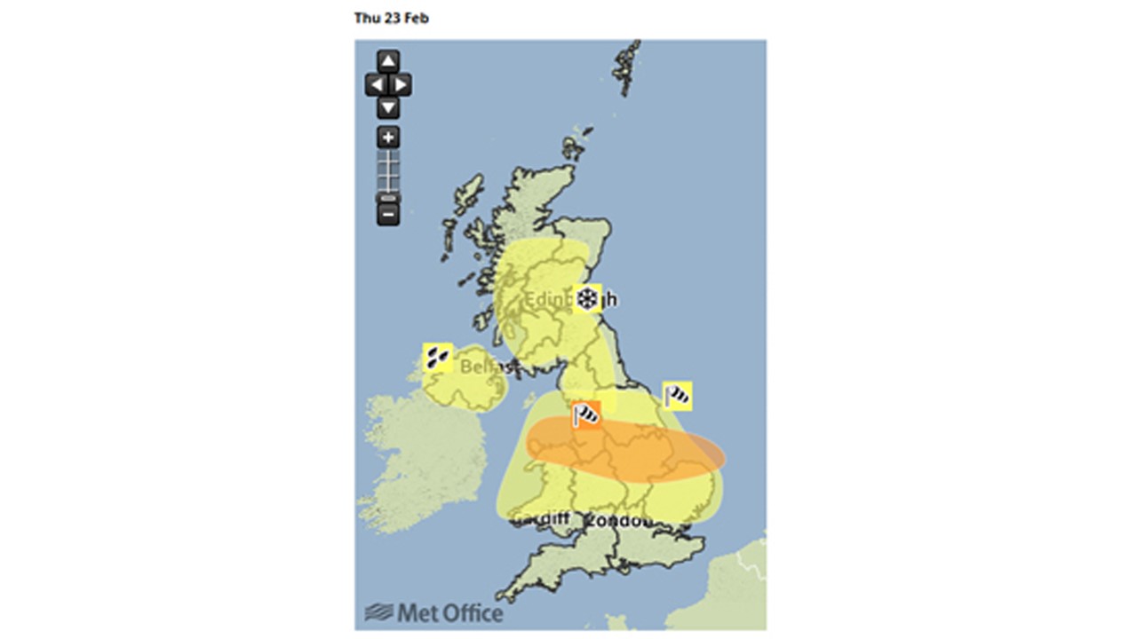
Much of the rest of England and Wales will see gusts of 50-60mph, covered by a Met Office yellow “be aware” warning.
Heavy rain and hill snow additional hazards
As well as very strong winds, heavy rain is expected to sweep eastwards, bringing a risk of localised surface water flooding for a time.
There will also be some snow over the hills and mountains of northern England and Scotland, where as much as 10-20cm could fall. This combined with strong winds will give blizzard conditions.
In addition, there could be snow falling to sea level north of the Central Lowlands in Scotland.
What’s causing Storm Doris?
At the moment, there’s swift-moving jet stream 30,000ft above the Atlantic Ocean, travelling at around 140mph
This will suck air upwards from the surface, causing pressure to fall quickly and form Storm Doris on Thursday.

The jet stream will also push Storm Doris quickly across the UK, which is why the worst winds will be short-lived.
What will the main impacts be?
Gale-force winds could potentially disrupt transport and power supplies, bring down trees and cause some structural damage in places hit by the strongest gusts.
Heavy rain may bring some localised surface water flooding on roads for a time as the storm moves through.
For areas affected by snow combined with strong winds, poor visibility and slippery roads will be a problem.
Given that the arrival of Storm Doris is two days away, there will be changes in detail during the next 24 hours, so it is worth keeping a close eye on the forecast.
Don’t forget, you can get the latest five-day forecast on the Channel 4 Weather website. I’ll also be posting updates on Twitter – @liamdutton