Australia braced for powerful Tropical Cyclone Rusty
 Liam Dutton
Weather Presenter
Liam Dutton
Weather Presenter
As New South Wales mops up after flash floods, another spell of severe weather is on the way for northern parts of Western Australia in the coming days.
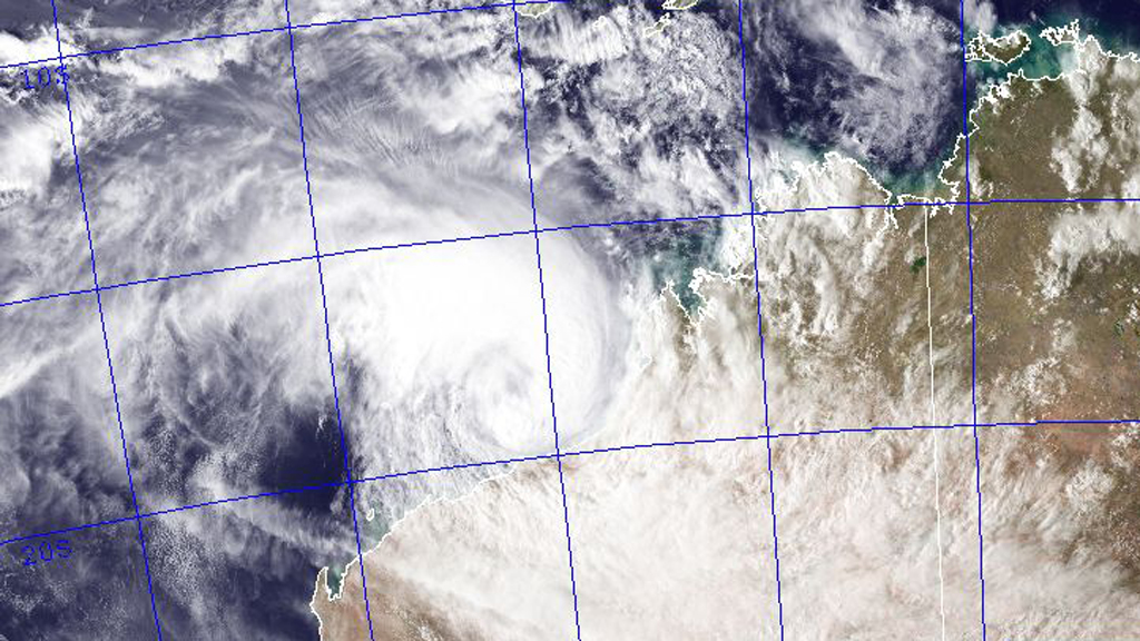
Tropical Cyclone Rusty is over open water around 130 miles north of Port Headland, rapidly strengthening as the storm draws up energy from the warm ocean.
Currently a category 2 cyclone, further development means that within 24 hours, Rusty will reach category 4, with sustained winds of 115mph and gusts of around 150mph.
The Australian Bureau of Meteorology is warning that this large cyclone and its slow movement will likely to result in rainfall that is heavier than that typically associated with a cyclone.
Very heavy rainfall is expected to fall near coastal parts of the eastern Pilbara and western Kimberley over the next few days, with 200-300mm, locally more, of rain possible in some areas. The heavy rainfall is expected to cause major flooding in the De Grey catchment.
As well as flooding caused by intense rainfall, the cyclone is expected to lead to a very dangerous storm tide as it approaches the coast, with waves as high as 5 metres slamming into the coastline.
The approaching cyclone has already led to Apache Energy stopping production from its Stag oil facility off the coast of Western Australia on Monday.
Port Hedland, a major terminal for iron ore exports, has been closed and all vessels sent out to sea in preparation for Rusty’s arrival, according to port spokesman Steed Farrell. Further south, Dampier port is expected to be fully closed by sunset on Monday.
Whilst there is still some uncertainty as to exactly where the cyclone will make landfall, warnings have been issued for residents to take action and be ready to take shelter.
Authorities are advising people to organise an emergency kit including first aid kit, torch, portable radio, spare batteries, food and water.
After making landfall, Rusty is expected to gradually weaken, but will still give torrential rain and a risk of flooding to inland parts of Western Australia until later this week.
Image courtesy of Naval Research Lab
-
Latest news
-
Laughing Boy: New play tells the tragic tale of Connor Sparrowhawk5m

-
Sewage warning system allows some of worst test results to be left off rating system, analysis shows3m
-
Post Office inquiry: Former CEO didn’t like word “bugs” to refer to faulty IT system4m
-
Israeli soldier speaks out on war in Gaza12m
-
PM’s defence spending boost should be ‘celebrated’, says former Armed Forces Minister4m
-


