What is a super typhoon? The key questions
It could be the most powerful storm ever to make landfall. But what causes super typhoons like Haiyan to form – and what will it do next?
A typhoon is a tropical cyclone – a storm system that spins in a circle. A cyclone is known as a typhoon if it forms in the north west Pacific.
Cyclones can also be known as hurricanes, tropical storms, depressions and cyclonic storms, depending on which ocean they form over and how severe they become.
A super typhoon is a storm that reaches sustained windspeeds of at least 150mph.
How powerful is Haiyan?
Some meteorologists measured sustained winds of almost 195mph and gusts of up to 235mph when Haiyan hit the central islands of the Philippines today, leading to claims that the storm is the most powerful ever to make landfall.
Dr Norman Cheung, an expert in tropical storms and disaster management from Kingston University, said: “It is absolutely true. This is the highest wind speed ever seen when a storm makes landfall. When it is over the open ocean that is another story.”
The previous record for the strongest cyclone was held by Hurricane Camille, which hit Mississippi with 190mph winds in 1969.
Dr Cheung said record high sea temperatures and low vertical wind shear – sudden changes in wind speed and direction – had combined to make the perfect conditions for Haiyan.
Why is it called Haiyan?
The Japan Meteorological Agency names cyclones in the north west Pacific, based on names nominated by the 14 members of the World Meteorological Organization’s typhoon committee.
Haiyan is one of ten names provided by China and is the Chinese name for the petrel sea bird.
The authorities in the Philippines assigns alternative names to cyclones that stray into their territory, hence the fact that Haiyan is being referred to locally as Typhoon Yolanda.

How do typhoons form?
Typhoons are fuelled by warm seawater evaporating and rising before condensing into clouds and rain when it meets cooler air.
The earth’s rotation makes the cyclone spin rapidly, clockwise in the southern hemisphere and anticlockwise north of the equator.
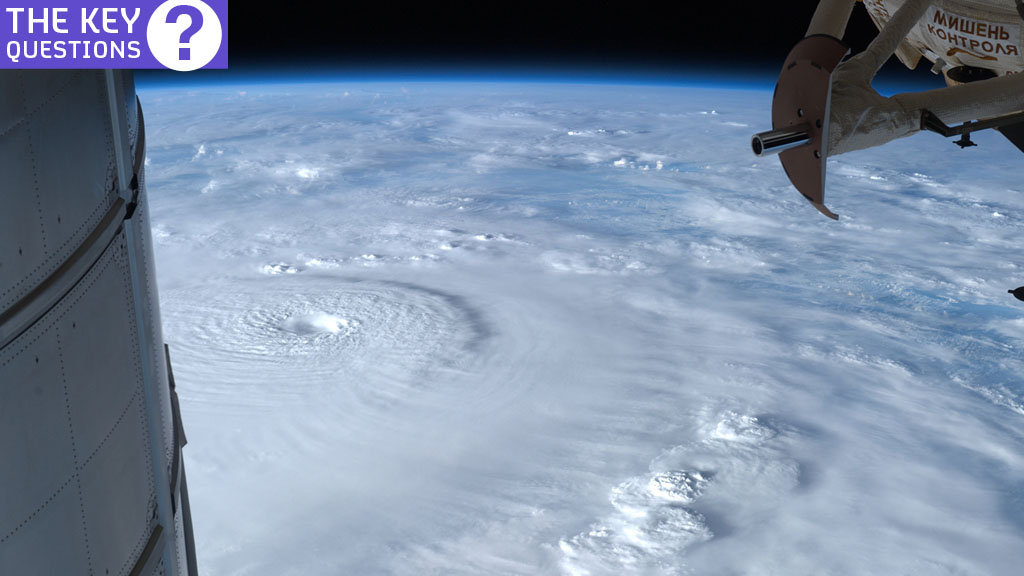
If a cyclone is strong enough, air sinks rather than rises at the centre, causing the famous “eye” – an area of calm that can stretch for hundreds of miles in diameter in the biggest storms.
The “eye wall” surrounding it brings the strongest wind and heaviest rain.
What happens next?
Typhoons tend to weaken when they hit land, so the storm could lose force as it passes over the Philippines. The storm has now made three separate landfalls, hitting the Northern Panay, Northern Leyte and Cebu regions.
Some meteorologists are predicting that Haiyan will gather more fuel as it leaves the proceeds north west towards Vietnam and China over the South China Sea, potentially making it even more dangerous.
But Dr Cheung said lower water temperatures in the South China Sea make that scenario unlikely.
He said: “I don’t think it will intensify. From what I have observed, I think it will go down to perhaps tropical storm rather than super typhoon level, with wind speeds of 120 to 130mph.”
We will only be able to assess the full damage to the Philippines when the storm has passed. Although the region suffers more typhoons than any other country, the sheer power of Haiyan could overwhelm the country.
Dr Cheung said: “This storm is so severe, and they are in a low-lying area. The impact will be huge and the damage could be huge.”
-
Latest news
-
As India goes to the polls in the world’s largest election – what do British-Indians think?6m

-
Tees Valley: Meet the candidates in one of the biggest contests coming up in May’s local elections4m
-
Keir Starmer says public sector reform will be a struggle7m
-
Nicola Sturgeon’s husband Peter Murrell charged with embezzlement of funds from SNP1m
-
Ukraine might finally get $60billion in American weapons and assistance to defend against Russia3m
-


