Gales and tidal surges: one dead as thousands evacuated
A lorry driver dies in Scotland and homes are evacuated on the east coast of England as the UK braces for the the worst tidal surge in 60 years.
Four other people were injured when the lorry overturned on to a number of cars on the A801 one mile north of Boghead Roundabout, Bathgate, West Lothian, at around 8.10am.
Motorists have been warned not to travel due to “extremely dangerous” road conditions.
Meanwhile, 15,000 homes in Great Yarmouth were evacuated after officials warned that the lives of people in the region could be at risk from the worst coastal tidal surge for over 60 years.
Read more: Sandbags and wellies - community battles the tidal surge
And more than 1,000 homes in Suffolk were evacuated ahead of the tidal surge.
Suffolk County Council said where possible, people living in areas that have been issued severe flood warnings should make arrangements to stay with family or friends outside of the affected areas.
The Environment Agency (EA) issued 28 severe flood warnings – the highest possible warning, meaning floods could endanger people’s lives.
The warnings are only issued when flooding poses a “significant” threat to life.
TRAVEL UPDATES
Trains: The weather caused chaos to the rail network, with services for the entire of Scotland and parts of the north of England suspended www.nationalrail.co.uk
Roads: Closures, fallen trees, minor accidents and incidents of flash flooding also affected the road network in parts of the country http://www.highways.gov.uk
Met Office: For the latest information about how different parts of the country are affected www.metoffice.gov.uk
London travel: www.tfl.gov.uk
Flooding: The Environment Agency has issued 28 severe flood warnings www.environment-agency.gov.uk
As expected, a deep area of low pressure has brought stormy weather to northern parts of the UK today. Scotland has bore the brunt of the winds so far, with gusts of 80-90mph in towns and cities, and in excess of 100mph over the hills.
Northern Ireland, along with northern parts of England and Wales have also seen strong gusts in the range of 60-70mph.
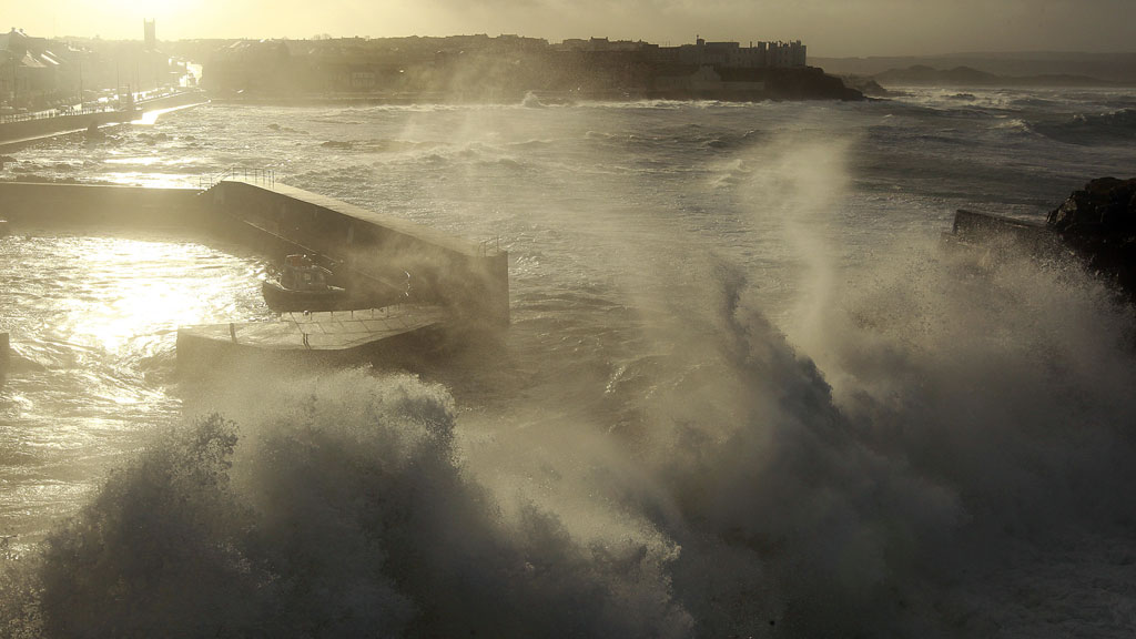
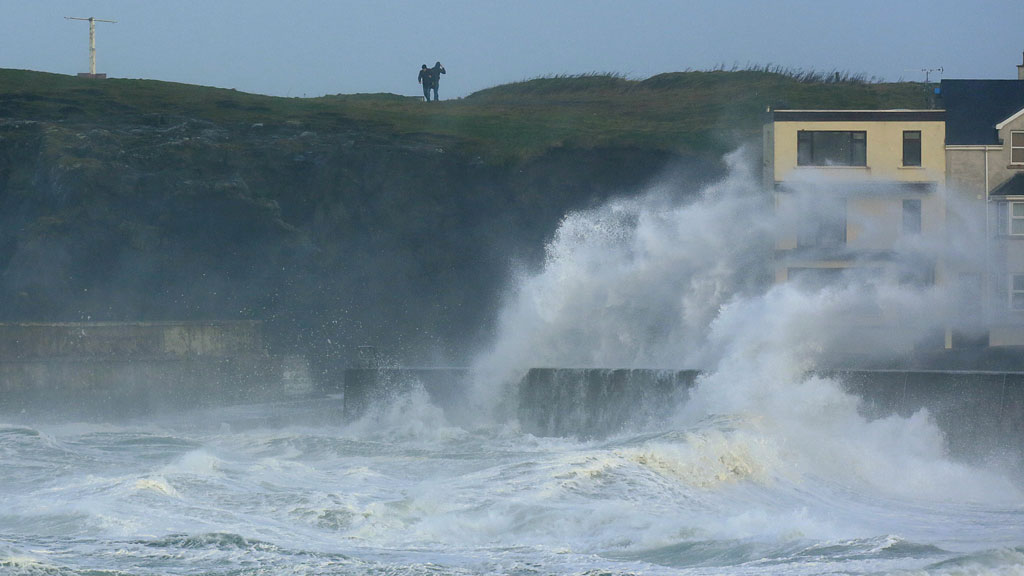
Whilst the winds over land will ease this afternoon, they'll remain very strong over the North Sea, which will bring the next potential problem through tonight and tomorrow - coastal flooding.
Large waves generated by the storm will be pushed onshore by strong winds, coinciding with high tides and causing a surge of water along North Sea coasts.
The Environment Agency and SEPA have issued a number of flood warnings from coastal parts of south east Scotland down to Kent, highlighting the areas at greatest risk.
Channel 4 News Weather Presenter Liam Dutton
AREAS AT RISK
The Essex coast from Clacton to Lee Wick.
The Norfolk coast at Walcott.
Some riverside properties on the estuary of the River Deben in Suffolk.
Waterside properties in Mistley, Essex and Brantham, Suffolk.
The quay area in Ipswich, Suffolk.
Felixstowe Ferry and the quay at Bawdsey in Suffolk.
The Deben Marshes, near to Felixstowe Ferry, in Suffolk.
West Mersea, The Strood and adjacent marshland, in Essex.
Southwold and surrounding marshes in Suffolk.
The villages of Snape and Iken and surrounding marshland in Suffolk.
The Suffolk village of Blythburgh.
The seaside area of Aldeburgh and Thorpeness in Suffolk.
The Riverside Business Park and Kirkley near Lowestoft in Suffolk.
Oulton Broad near Lowestoft in Suffolk.
The south bank of Lake Lothing, Bourne Business Park and Mutford Lock, near Lowestoft in Suffolk.
The north bank of Lake Lothing, near Lowestoft in Suffolk.
Parts of the River Bure in Norfolk.
Lowestoft seafront and docks, in Suffolk.
Four severe flood warnings for different parts of the River Yare in and around Great Yarmouth.
The north Norfolk coast at Salthouse.
The north Norfolk coast at Blakeney.
The north Norfolk coast at Wells quay.
The quay area of Sandwich in Kent.
The Greenfield to Bagillt area on the north Wales coast.
Point of Ayr on the north Wales coast.
WHAT IS A STORM SURGE?
A storm surge is a very localised rising of sea level - independent of tides - related to the track of a storm and its accompanying winds.
The storm causes this surge of water in two ways. Firstly strong winds, often blowing parallel to the coast or onshore, push water roughly in their direction which causes water to 'pile up' on nearby coasts.
The second element, which is less important for the UK, relates to differences in air pressure. Low pressure, associated with storms, exerts less of a force on the sea surface - allowing the sea surface to temporarily rise in the vicinity of low pressure.
Local geography also plays a role. North Sea areas are particularly prone to storm surges because water flowing into the shallower southern end cannot escape quickly through the narrow Dover Strait and the English Channel. The shallow depths in the southern North Sea also aid the development of a large surge.
When storm surges combine with high tides, especially spring tides, and large waves they can cause flooding issues along coasts.
POWER CUTS
Tens of thousands of properties across the country were also hit by power cuts as winds of up to 140mph battered powerlines.
Northern Powergrid said that 55,000 homes have been affected since midnight and 25,000 properties in the north east, Yorkshire and North Lincolnshire are still without power.
The Met Office said there had been severe gales of between 60mph and 80mph across Scotland and northern parts of England, and some mountainous regions in Aberdeenshire and Inverness-shire reported speeds of around 140mph.
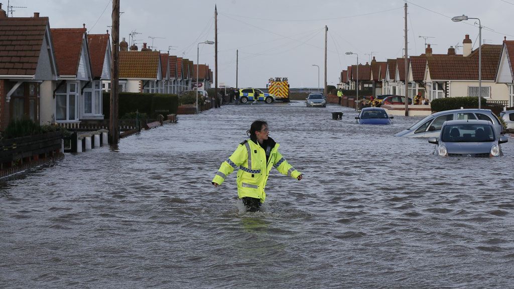
Homes evacuated
People in affected areas are urged to stay in a safe place with a means of escape and be prepared should they need to evacuate their homes.
Severe flood warnings are currently in place across Kent, Norfolk and Suffolk.
People along the eastern coast, and some parts of the north west coast, are being urged to take urgent action to prepare for flooding on Thursday and into the early hours of Friday. The Environment Agency is likely to issue further severe flood warnings in the coming hours.
Some defences could be overtopped by the combined effect of high tides, high winds and a large tidal surge.
‘Devastating floods of 1953’
In some areas, sea levels could be higher than those during the devastating floods of 1953.
The 1953 floods led to the deaths of nearly 2,000 people across the United Kingdom, Belgium and the Netherlands, but the Environment Agency said that flood defences mean that “many parts of the country are much better protected than in 1953.”
The Environment Agency will be closing its Thames Barrier on Thursday to defend London, in addition to operating numerous other defences such as those at Colne in Essex and Kings Lynn in Norfolk.
Farmers are being urged to protect their livestock and consider moving them out of affected areas.
John Curtin, the Environment Agency’s Head of Incident Management, said: “Flooding of coastal communities along the eastern and north west coasts is expected today and into Friday. Some defences could be overtopped by the combined effect of high tides, high winds and a large tidal surge.
“People are being urged to check the Environment Agency website or follow @EnvAgency and #floodaware on Twitter for the latest flood outlook, and to sign up to receive free flood warnings.
“The Environment Agency continues to monitoring the situation closely, working alongside partners including the emergency services, Met Office and local authorities. Our teams have been out in force checking that flood defences and barriers are in good working order, monitoring sea levels and issuing flood warnings.
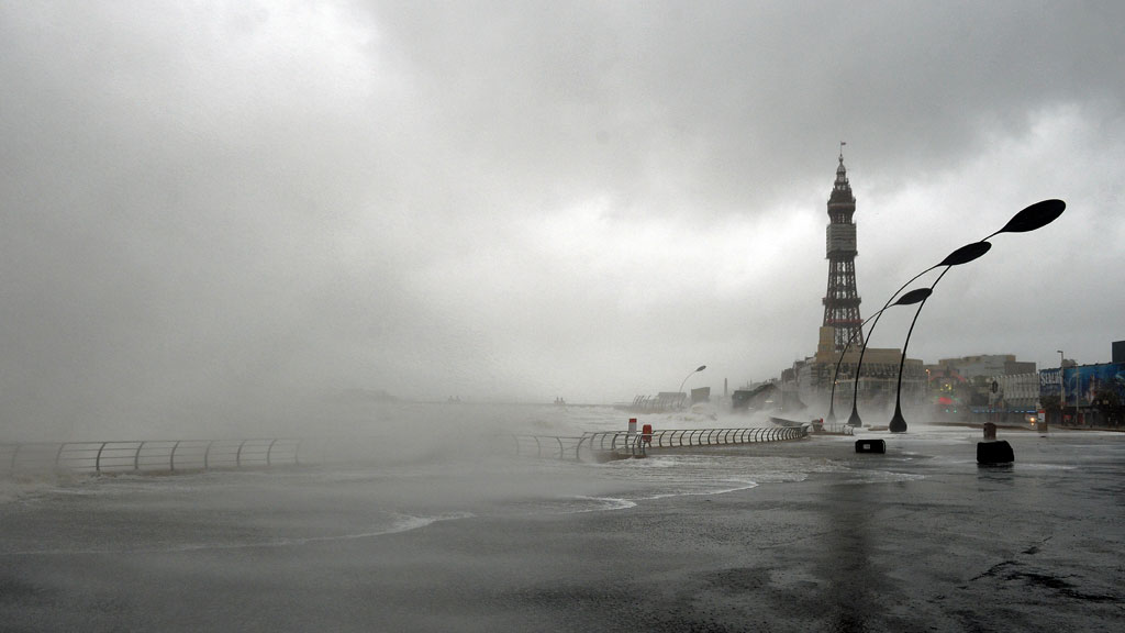
“Coastal paths and promenades will be highly dangerous as there is an increased risk of people being swept out to sea.”
Dr Paul Leinster, chief executive of the Environment Agency, said: “Gale force winds and large waves along the east coast of England are forecast during Thursday and Friday, coinciding with high tides and a significant coastal surge.
“Flooding of some coastal communities is expected and some defences could be overtopped by the combined effect of high tides, high winds and a tidal surge.
“Coastal paths and promenades will be highly dangerous as there is an increased risk of people being swept out to sea.
“The Environment Agency is monitoring the situation closely, working alongside partners including the emergency services, Met Office and local authorities.
Have you been affected by the storm? Upload your picture to the weather gallery here.
-
Latest news
-
Laughing Boy: New play tells the tragic tale of Connor Sparrowhawk5m

-
Sewage warning system allows some of worst test results to be left off rating system, analysis shows3m
-
Post Office inquiry: Former CEO didn’t like word “bugs” to refer to faulty IT system4m
-
Israeli soldier speaks out on war in Gaza12m
-
PM’s defence spending boost should be ‘celebrated’, says former Armed Forces Minister4m
-


