Iceland’s ash cloud: how bad is it?
The area around Grimsvotn is shrouded in a gloomy pall of volcanic ash, Science Correspondent Tom Clarke reports from Iceland. But how does it compare to last year’s ash cloud?
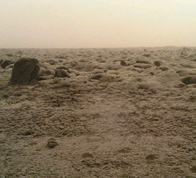
Around 30 miles from the volcano it starts to get so thick it completely blocks out the sun.
There is a fierce wind, too, and the combined effect is to make Iceland’s lunar surface look even darker and inhospitable.
Roads have been closed and some locals have left their homes to avoid the thick abrasive ash.
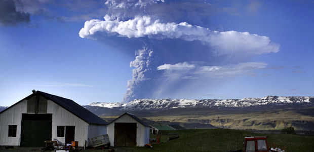
The eruption from Grimsvotn has diminished from its peak at the weekend. On Sunday the ash cloud was being thrown a staggering 20 kilometres (12 miles) into the sky – it is now only 5km high.
That’s good news in terms of the potential for long-term disruption to flights across Europe, but it doesn’t mean the risk of travel chaos in the coming days has subsided too.
This eruption is still the largest in Iceland in 60 years, and the main ash plume from the volcano is only beginning to disperse. Its leading edge is now over Scotland and the north of England, and there is a chance higher concentrations of ash could extend across England and Wales late in the week.
 In pictures: Icelandic ash cloud
What’s more, the height of the plume may seem less than it actually is due to high winds which may, researchers warn, be making it look less extensive than it actually is.
The sheer volume of ash means there is the potential for further disruption – but there are a few key differences between this eruption and that from Eyjafjallajokull last year which caused such widespread and long-term chaos.
The ash from this volcano – though more of it has been flung higher into the atmosphere – appears to be of a heavier and more grainy. That means it will fall back to earth before it spreads across too much of Europe’s airspace.
Live blog: latest as the ash cloud spreads across Britain
The weather patterns also look more favourable. When Eyjafjallajokull was erupting, steady winds brought the ash towards the UK for weeks on end. Right now the weather is much less predictable but it looks that winds will continue to shift through this week, meaning it is unlikely a steady stream of ash will be brought to the UK.
It also looks like forecasters are better equipped to predict the ash cloud’s behaviour this time.
There are radar instruments now on the ground in Iceland that are allowing them to monitor the height and density of the ash cloud. This information was unavailable for last year’s eruption but is essential if you are trying to predict how far the ash might go and how thick it might end up being.


